This past summer, I road-tripped through Northern Arizona. If you've ever been to this area, then you know about interstate highway 89A.
This is not the small, state highway 89A between Sedona and Flagstaff. Interstate 89A runs from Bitter Springs, Arizona to Kenab, Utah. It's known by the state of Arizona as the the Fredonia-Vermilion Cliffs Scenic Road. Why? It passes right by those cliffs and through the town of Fredonia—clever!
There was much to see along this 2-hour stretch of road. There were gorgeous views of rivers and deserts, forests on fire, and rural towns. In this post, I describe these and more of the most notable parts of the drive.
1. Marble Canyon / Navajo Bridge
The start of interstate 89A takes you North across a vast plain with distant views of cliffs. It then turns East across what seems like a rather unremarkable bridge. In fact, this bridge has a view you do not want to miss.
The Navajo Bridge is actually two bridges. One bridge is for vehicles and the other is for pedestrian traffic only. They are steel arch bridges spanning the Colorado River. The river carves out Marble Canyon below.
I could not glimpse the canyon or river from my car while crossing the bridge. This is why I missed it my first time driving toward Utah with Erin. We didn't think much of it. I decided to stop on my way back, though, and I have to say it's worth it! The contrast in color of the river against the yellow-orange canyon walls is stunning. And the only way to see it is to park in the visitor's lot and walk across the pedestrian bridge.
I'm happy I took a few extra minutes on my drive to see it!
2. Cliff Dwellers Stone House
Not a minute along 89A from Navajo Bridge is one of Arizona's ghost towns: the Cliff Dwellers Stone Houses.
This is a unique, identifiable site because of it's odd-shaped rock formations off the side of the road. Erin and I spotted it and made the quick decision to stop.
We learned that, in 1927, a woman named Blanche Russell's car broke down here. After camping overnight, she liked the scenery so much she bought property and stayed. These stone structures are the remnants of her shelter, including a restaurant. She would feed tourists who passed through and even gassed up their cars from a gravity fed pump.
It's a strange little stop and fun to walk into these vacated stone structures.
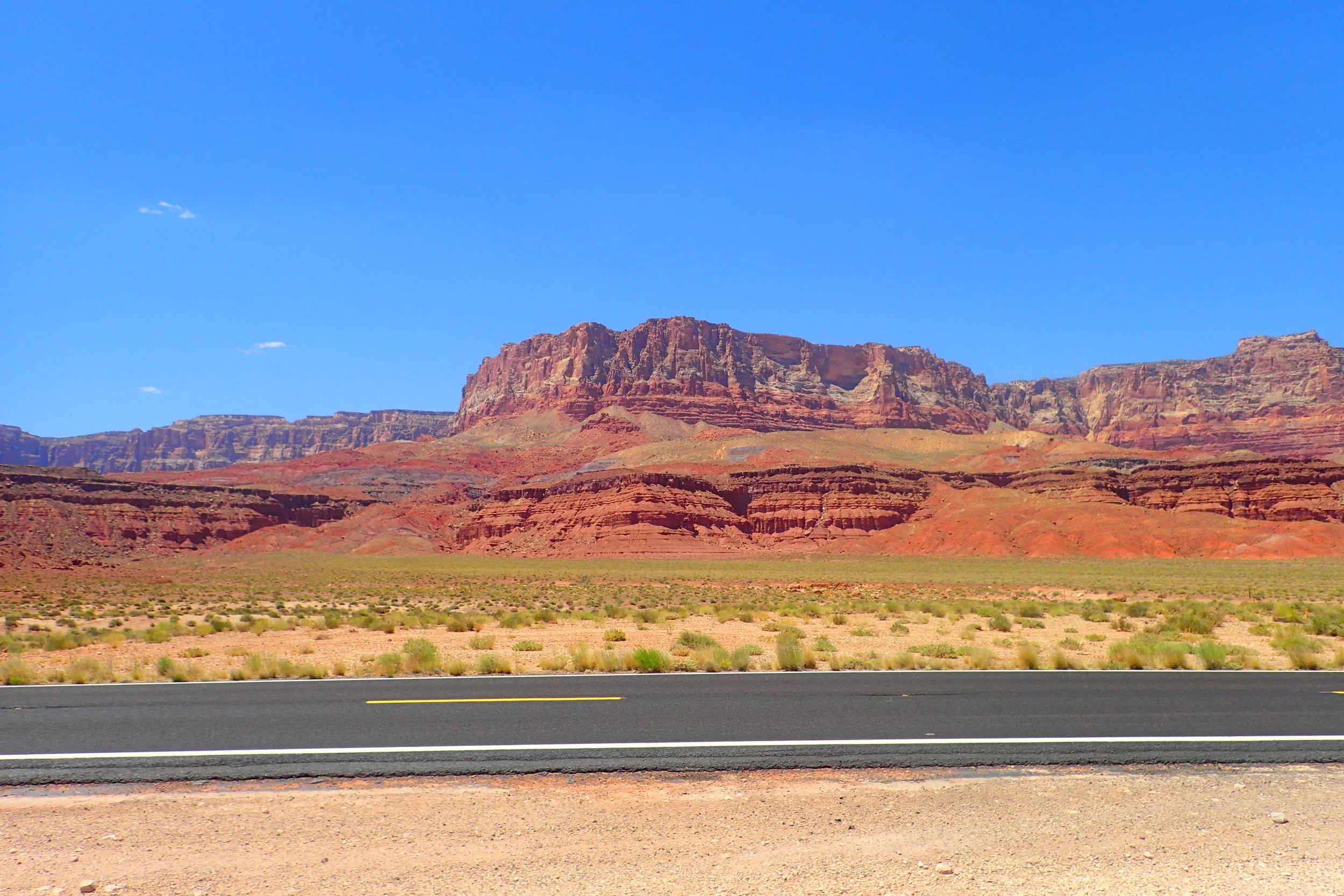
3. Vermillion Cliffs
Those distant cliffs I referred to earlier are the edge of the Vermillion Cliffs. There are many points along the start of 89A where you will have a perfect view of them.
The Vermillion Cliffs are a great expanse of "escarpments" or steep slopes that make up part of a plateau. They are the second level of the great Colorado Plateau which extends into Utah and even all the way to Canada.
The cliffs stretch for many miles out across Arizona from what you see in these photos. They form great mesas and tablelands and have elevations up to 3,000 feet from their bases.
Their varying coloration of reds and purples change with the angle of the sun. I wish I had the chance to see them around sunrise or sunset. I bet they are beautiful at every time of day!
4. Pasture Canyon Lookout
About 30 miles from Navajo Bridge along 89A is a great spot to pull your car over and catch some views.
There is not much at the lookout. There is space for many cars to stop and a couple of sign posts about the area. But you can walk down a small, dirt trail off the main parking area. The trail will take you to a small, yet beautiful canyon hidden in the valley below.
5. Kaibab National Forest on fire!
Kaibab National Forest makes up 1.6 million acres bordering the Grand Canyon. It's enormous and offers tons to do in the way of camping, fishing, hiking, cycling, and more.
While I was there, Kaibab was on fire! Arizona was experiencing a lot of bad fires at the time. I could see fires in the distance from my flight into Phoenix days earlier. Temperatures were reaching crazy heights at the time—around 107F. In the days before my arrival, images of mailboxes melting on the streets of Phoenix were popping up on the web.
Erin and I entered Kaibab National Forest on 89A and spotted the evidence of wild fires. We stopped at one location to get a full assessment of the damage.
The fires had flatted entire sections of the forest leaving behind charcoal ashes. The remaining trees in the area had black scars telling the story of what had been there only days before.
Seeing the damage first hand was sobering.
6. Le Fevre Overlook
This is a great spot to stop, stretch you legs, take a bathroom break, and catch an awesome view.
Le Fevre Overlook provides a view of the entire "Grand Staircase." The Grand Staircase consists of layers of sedimentary rock stretching down from Utah. The layers go from Bryce Canyon in Utah all the way to the Grand Canyon in Arizona.
At Le Fevre Overlook, you'll see a vast plateau backdropped by cliffs over the border into Utah. It's a view you'll get as you descend out of Kaibab and make your way to one of the first towns before crossing the border.
7. Fredonia – We're Not In New York Anymore
Fredonia is one of the first towns you will pass through along 89A before entering Utah. And it's a true, small, American town with a population of about 1300. It's racial makeup is 85% White and 11% Native American.
One of the welcoming businesses as you pull into Fredonia is this establishment:
All the vices. At one location. For your convenience.
As I drove through this town, I thought of another town called Fredonia back home in New York State. Fredonia is in western NY near Lake Erie. I've never been to Fredonia, NY. But, as a college town with a population of over 11,000, I am sure it's nothing like Fredonia, AZ!
8. The Border into Utah
At the border of Arizona and Utah on 89A, there is a little roadside stop that's worth a few minutes. First of all, I love the sign here for Utah. The state of Utah's slogan used to read "Enter a higher state. In 2006, they changed it to "Life Elevated" and I love it!
Utah is definitely elevated. It's mean elevation ranks 3rd highest above sea level in the nation. At 6,100 feet, Utah follows neighboring Colorado and and Wyoming.
Next to this sign is a large area to park you car and check out a little table set against the back. These tables have petrified wood for sale using an honesty box. From $0.25 to a few dollars, you can pick out some pieces that a local collected and placed here. A nice little keepsake. I picked a couple out for myself and friends back home.
Missed Opportunities
There are many turn-offs from 89A that will take you to some popular destinations. But I either didn't have the time to do it or I was able to access the areas for various reasons.
Plan in advance, and you'll be able to catch some of the most hyped up areas off 89A:
The North Rim of the Grand Canyon
Turn off 89A onto Rte 67 or "Grand Canyon Highway" while driving through Kaibab Forest. This will take you to the less visited north rim. Only about 10% of Grand Canyon visitors ever check out this view of the canyon.
There is only one lodge and one campground here. So plan ahead if you want to stay overnight. You may catch a couchsurfer there, too. I almost stayed with one before deciding to stay in Flagstaff instead.
The Wave
The Wave is a stunning location in the North Coyote Buttes of the Paria Canyon Wilderness. People often stay in Kenab looking to go on a tour of the Wave. Only, they find out they can't go.
I thought I was planning ahead super far in advance when I started in April looking at tours to the Wave. My trip was for late June. That's when I discovered that the Wave is only accessible with a permit. And you have to apply for the permit at least 4 months in advance. The $5 application fee per group adds insult to injury.
Only 20 people are allowed access per day. The government has good reason for limiting access. They want to preserve the area. At the same time, they bring in a lot of revenue by hyping the place up. I mean, it's a stunning location. If you obsessed over my photos from Antelope Canyon, you'll melt with envy over photos from the Wave.
Your only other chance besides applying in advance is a walk-in lottery. The lottery takes place on the first of every month. If you're a solo hiker as opposed to a pair or group, your chances at the lottery are higher. If you win, you pay $7 as an individual to go.
Plan ahead! More information about the permits and lottery are here.
White Pocket
White Pocket is not a restricted area like the Wave. And some find it to be similar in beauty. The only downside is you must have a 4 Wheel Drive (4WD) vehicle if you want to hike White Pocket on your own.
The availability of 4WD vehicles is limited and the cost is high. The lowest I saw was around $185 per day. And that's around the price of a tour to take you to see it anyway!
Because of the cost and difficulty getting there, I opted not to go. Utah and Arizona both had so much other beauty to see. I didn't need to get hung up on another hyped location.
In Conclusion
Interstate 89A has some unique and beautiful sites to see. The drive is only about 1.5 hours on a straight shot. But allow for some time to make stops. You won't regret it!