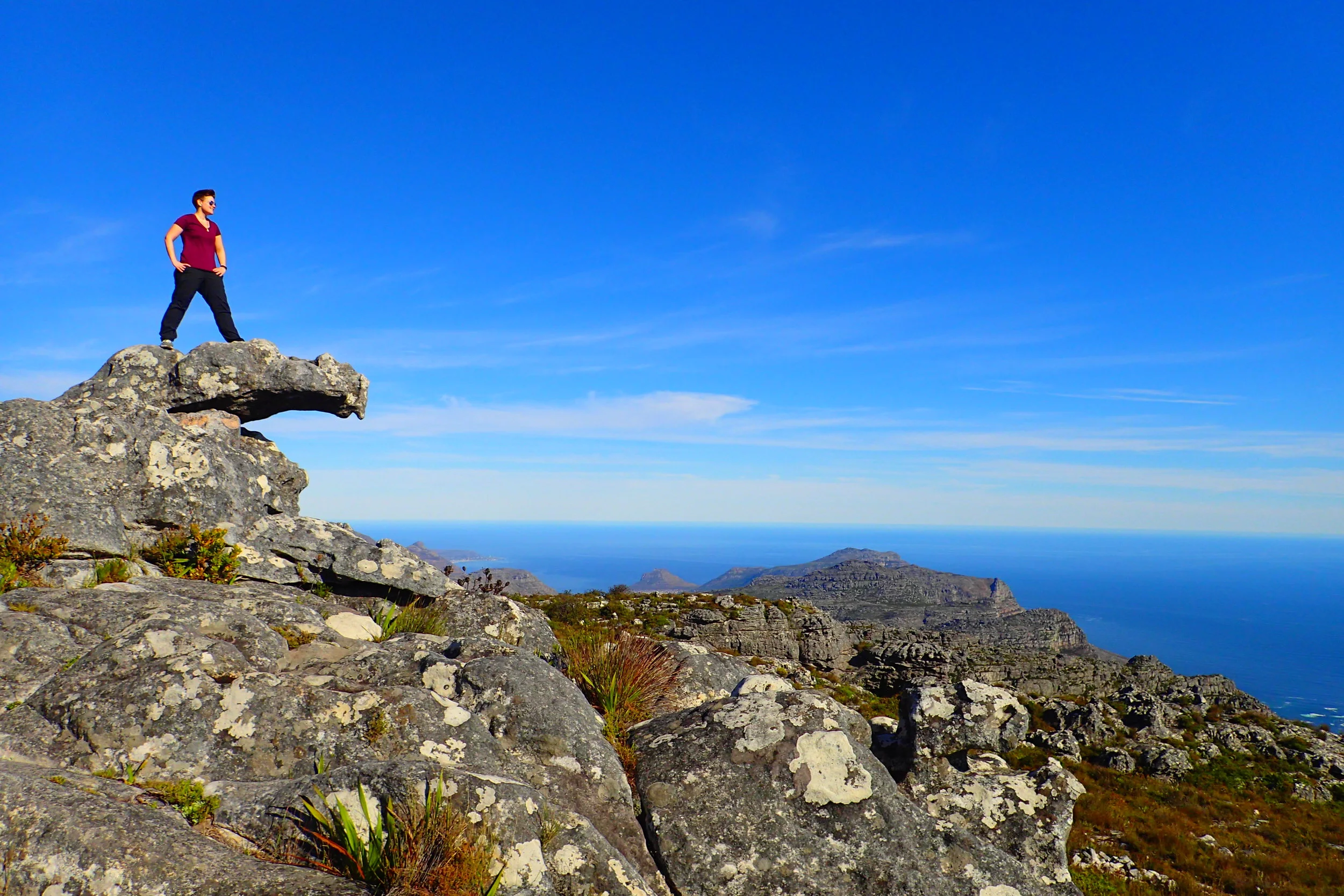
Table Mountain is iconic to Cape Town, South Africa. Reaching the summit of Table Mountain is necessary to complete any visit to Cape Town.
I chose to hike Table Mountain on my second to last day in Cape Town. This hike challenged me with its constant upward incline. But the views were immediate, making it worth every ounce of sweat!
Below, I take you on my journey while answering some common questions about this iconic hike. Take it all in and consider it a must-do for when you visit Cape Town!
What And Where Is Table Mountain
Table Mountain is in Cape Town, South Africa. It forms a backdrop to the city when looking southwest toward the Atlantic Ocean.
This is a world heritage site and one of 7 "new wonders of the world." Table Mountain formed when continents split after the ice sheets flattened sandstone into its surface or "table top."
The mountain is famous for the "tablecloth," or orographic cloud, formation that sometimes dwells around it. The best days to hike Table Mountain are when the tablecloth is not there. The views are clear and the pathway to the top is easier to navigate when the mountain is free of its tablecloth.
Why Choose Plattegklip Trail
There are many entry points and trails around Table Mountain National Park. I chose Platteklip. It was a short ride from my Airbnb and offers challenging switchbacks and great views along the way.
Platteklip Trail is the oldest and quickest easiest way to hike up to the summit. Although I wouldn't say it's easy!
The most notable part of the experience for me was the excellent views of the city below. The entire hike offers these views and they don't quit!
How To Find Platteklip Trailhead
The morning after meeting Rad, I took an uber to the trailhead for Platteklip Gorge. An uber or cab will bring you directly to the trailhead or the hop on/off bus system around Cape Town will get you close. Taking the bus will drop you on Tafelberg Road at the cable car station nearby.
Platteklip Trail is on Tafelberg Road in Table Mountain National Park. The trailhead will be on the right about 1 mile east along the road from the cable car bus stop.
Platteklip Trail is free to hike and you don't need a guide. Once you reach the top, you'll have the choice of taking the same trail, a different trail, or a cable car back to the bottom!
How Challenging Is Platteklip Trail
I hiked this trail in South Africa's winter. But it was still quite hot even before 10AM when I went. Sun exposure creates a challenging temperature.
There was not much cover from the sun until I got between the gorge during the last 30 minutes or so. There was a drip of water down the cliff face while I was there. This cool, damp area was so very welcomed after over an hour of complete sun exposure.
I got hot and sweaty and head-poundy on this trail also because of the many "steps" and consistent incline. The climb can be dangerous for this reason.
While Platteklip Trail is the quickest way up the mountain, it's a 2300 ft elevation gain over less than 2 miles. So it's a steep incline. I paused frequently to allow my burning quads to calm down a bit.
People can get overwhelmed from exhaustion and lose their balance on this hike. That makes the hike a bit dangerous. I had my moments of dizziness but nothing kept me from my pursuit.
Designated a 2.5-hour hike to the top, I took about 1.75 hours to complete it. Not bad for being fat from 5 days of safari tour buffets! :)
How Are The Views On Platteklip Trail
View from bottom of trail of Cape Town, Lion’s Head, Signal Hill and ocean beyond
It's worth saying again—the views are great on the Platteklip Trail. The trailhead actually starts well above sea level. This means the views of the city below are worth it from the very start.
Of course, the higher you get the better the city and ocean views.
I also loved that I got to catch sight of the national flower of South Africa—the protea.
Although it was not in bloom in winter, they were everywhere and would add nicely to the landscape at the right time of year.
The view I liked most was looking up ahead at the gorge.
The gorge itself seems underrated and under-discussed in many reviews about the trail. Maybe it's because the entire mountain has these rock formations?
Either way, I obsessed over the rocks there. Their shape and lines all stacked on each other made it look like I was venturing into a medieval fortress!
All I could think to myself (in old-timey super-hero voice) was—"adventure awayyyy!"
What Is The REAL Summit Of Table Mountain
Once I reached the top of the Platteklip Trail, signs pointed out that I was not at the true summit yet. The highest point of Table Mountain is about 45 minutes to the east at Maclear's Beacon.
I took a few photos before heading out east. First, the view looking down the trail from the top was neat between the two gorge rock faces.
There also were some fun rocks to pose on and rest a bit before continuing my journey.
The hike out to the real summit is flat and simple. There was a nice breeze which I appreciated during the continuous sun exposure. There were excellent views all around on this hike—of Cape Town to the north and of the Cape of Good Hope to the south.
I knew I was reaching the summit when I saw an outcropping of boulders ahead along the path.
On top of the summit is a cairn and beacon marker. The plaque marks the highest point!
There were only about 5 people here at the summit with me and eventually they all left. I guess not too many people opt for this part of the hike?
I sat down for a little picnic by myself. At this point, I was happy to have layers to wear because I had cooled down a lot and the breeze had picked up. I chose to face south for views of the Cape of Good Hope. Gorgeous!
What's The Table Mountain Aerial Cableway
After returning from the summit, I made the decision to take a cable car back down the mountain. I wanted to have time to see some other parts of Cape Town. Plus, I wasn't looking forward to the descent down Platteklip again.
As I was making my way up Platteklip Gorge, there were a few hikers coming down the mountain. Many hikers concur that downhill is always much harder on the knees! Watching other hikers struggle as they picked their way down the steep steps made me reconsider my path down for the return.
I also just really wanted to experience the cable car! I've never been on one before to go up or down a mountain. So this was exciting to me!
To get to the cable car, I hiked another 10 minutes or so west of the Platteklip trail exit at the top of the mountain.
This took me to an area that was highly populated with tourists.
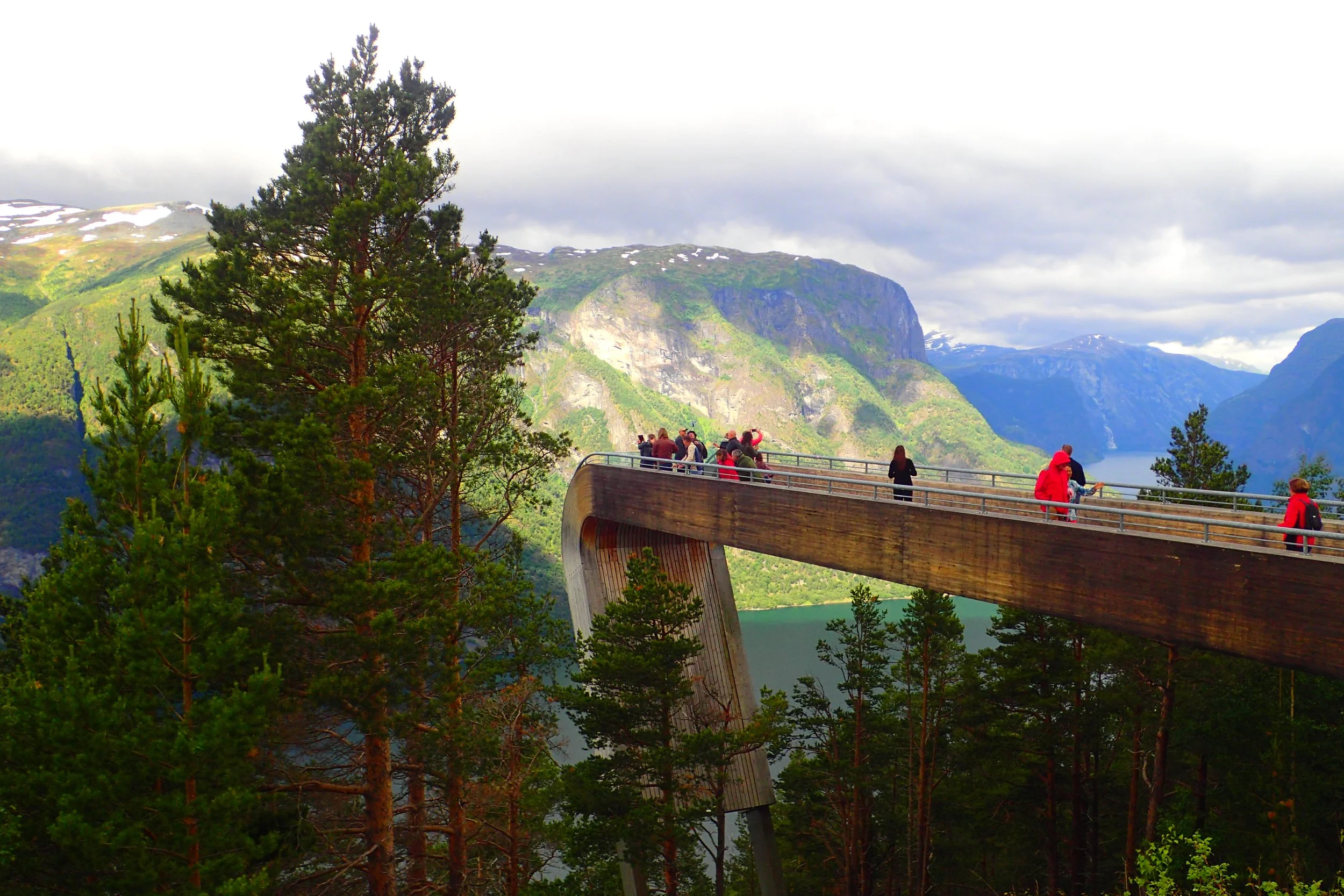
I love when mountain views are accessible to the many. The Table Mountain Aerial Cableway offers an easy way to reach the top without having to hike. This makes it very popular with tourists of all ages and abilities.
And the views here are so very worth it. You can see over Camps Bay to the west and Cape Town to the North.
Another sight you can see is Lion’s Head and Signal Hill.
On a clear day is Robben Island further North and out to sea. That's where Nelson Mandela stayed in prison. It's also where I was planning to visit the next day!
People catch the cable car who have a physical disability or who do not have time for a full hike. It's also a good option for people who are just feeling a bit lazy! A roundtrip ticket will set you back about R290 (~$20 USD).
I got a one-way ticket down. Any position in the car is great because it rotates as it goes for 360-degree views!
I loved it! Taking the cable car down gave me plenty of time to uber back into the city for some further exploration.
After you reach the bottom, you have the option to buy photos of your ride like at amusement parks. I didn’t feel this was necessary for me. But I can see it being a nice momento for a family, couple, or group!
In Conclusion
I recommend Platteklip Trail to anyone who is up for a challenging but fast hike. It's a great way to experience an iconic landmark of Cape Town and see some great 360-degree views of the Cape Peninsula.
Hiking up table mountain was a great experience. I also felt the hike out to the summit was worth it. It took some extra time, but I then saved time by taking the cable car back down.
Don't miss this experience even if you're only able to take the cable car up and back—it's worth it!


![Video Extras [Uncut] from My Icelandic Adventures](https://images.squarespace-cdn.com/content/v1/53b6ec86e4b09a1fb529c6b8/1461209434703-PUV03V33GYI7CZUHKQ2Q/P9041572.JPG)