
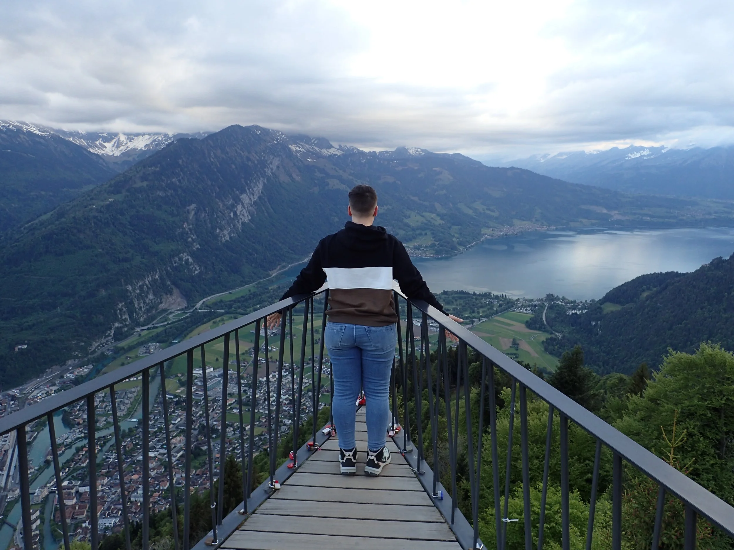
After I visited family in Germany, I continued my May 2026 euro trip. I visited one of the most stunning mountainous regions of the world: Interlaken, Switzerland. Snowy, craggy Alps surround this tourist town. Sitting between two lakes, Interlaken serves as a central railway link to many smaller alpine villages in the region.
Traveling there during shoulder season meant less crowds. I also imagine the costs of things overall were lower even though everything in Switzerland is expensive no matter what way you slice it!
The time of year that I went limited the options I had for hiking. I wasn’t able to hike most upper altitude areas. Alas, I still managed to access four epic viewpoints via hiking and cable cars. This post highlights how I accessed each, what they offered, and why Spring is a wonderful season to visit Interlaken.
Staying In Interlaken In May
I took a series of train rides from Germany and reached Interlaken in the early evening on a Thursday. I walked from Interlaken West station just a few blocks to Happy Lodge Inn where I checked into a 4-bed female dormitory. It was simple accommodation—just what I needed for being out and about for most hours of the day.
I wasted no time at all after arrival. I changed into some warmer layers and headed out in the direction of Höhematte Park. Walking along the northside of the park, I was already met with incredible mountain views.
My whole time staying in this part of Interlaken proved to be the perfect location. I was just a block from the central bus station to everywhere. My accommodation provided me with a free bus pass!
I had access to all of the main shopping, restaurants, and bars. There was a Coop grocery store right on the corner that I went to every day for snacks and to make my own meals.
This location was access and convenience at their best. And there was no avoiding the mountains. Sitting between the lake Brienz to the east and Thun to the west, the views were excellent from just about everywhere.
Gondola To Harder Kulm
Passing the park, I walked over the Beaurivage-Brücke, a bridge over the the Aare which is Swizterland’s longest river. Up against the mountain is a Gondola that takes you up to Harder Kulm. For a CHF 29.50 (~$38) round trip ticket, I rode to the top through a tunnel, enjoying views of Interlaken and surrounding mountains the whole way.
Harder Kulm is nicknamed the “Top of Interlaken” with panoramic views, a restaurant, and access to a ridge hike that was accessible at that elevation.
Since it was evening, I didn’t plan to do the hike. What I wanted were the views at sunset. Interlaken on average is about 55 degrees in the month of May, getting up to no more than maybe 65.
I was surprised to find lots of whimsical statues and artwork at the top, too. A few cartoonish Swiss people painted in bright colors, some flying the Swiss flag, and animals, like a fox and bird carved into wood, were planted along the walkways surrounding the observation deck.
The lakes and waterways were a bright turquoise, even with the sun setting. The green parks a were vibrant between the buildings and the ridged mountains were striking against the bright, cloudy sky. I captured the views from left to right, or east to west, facing the alps to the south.
The observation deck was filled with people—but not too many people! A short line formed in which every person who stood on the lien first served as photographer to the one(s) in front of them before they got their turn at a photo.
I took advantage of taking some selfies as I waited but the line moved quickly. Folks were extremely accommodating and willing to take all the photos people wanted (and on all their various devices) before moving on to their turn. We all shared the desire to get the photos we want while we can and supported each other in that goal. And everyone was just happy and feeling generous in the presence of such natural beauty all around us.
I’m grateful to those who too my photos, especially as a solo traveler!
Next to the observation deck was a drawing with all of the mountains on the horizon intricately labeled with their various names. There were so many!
As the sun set, the air grew colder. I was thankful for bringing extra layers with me. Interlaken on average is about 55 degrees in the month of May, getting up to no more than maybe 65. At night it can get down to the 40s and at higher elevations it can get colder still.
My plan was to stay until the last gondola ride down or until I got too cold to stay any longer. I put my packable parka on over my hoodie, my neck warmer, and hat. Immediately feeling warmer, I was also feeling pleased with what I chose to pack for this trip.
I sat down for a hot, margarita pizza at the restaurant as the clouds turned into pink cotton candy.
Before heading back down, I took advantage of there being nobody out on the observation deck anymore. I got the entire platform to myself. I stood on the end of it fully soaking in the views. The sun was gone behind the mountains now, and a call yelled out “last gondola!”
The ride down was so cool at twilight. The city was lit below and the tunnel felt like being in a haunted ride, blood red lights flooding the way.
It was a beautiful first evening in Interlaken. What a great introduction to this place!
I returned to my dorm at almost 10pm. The 3 other women in my room were already in bed, asleep or quietly on their phones. I tiptoed about as I prepared for bed. I was excited for my day the next day! I had a big adventure planned.
Hike Toward Breitlauenen From Wilderswil
It was already late in the day—2pm—when I decided to go on a hike on my second day in Interlaken. I'd spent most of the day hang gliding, something I’d always dreamed of doing since I was a little kid. But I’ll share more on that in my other post!
I wasn’t certain I’d be feeling up for a hike, but a sudden burst of energy motivated me. Initially, I wanted to get up to a peak called Schynige Platte. The special rail line that connects to it was not in operation until the summer season started. So I looked into how to get there by foot.
My research led me to identify a more remote trail from starting in Winderswil toward Breitlauenen. I didn’t think I’d have time to reach Breitlauenen before sunset, or before the predicted rain, I figured I’d hike as far as I could and then turn around.
I took the bus to the Winderswil stop, crossed over the Lütschine river, and entered the trailhead next to the Kirche Gsteig, a protestant church.
The hike immediately began an upward climb. It first spit me out onto a few sunsoacked hills alongside farms above Winderswil and Gsteigwiler. There were sheep running off in the distance and cows with their iconic Swiss bells ringing alongside the path.
I admired the wild flowers here, and I basked in the sunlight in these parts while I could. The way was otherwise completely covered by forest.
The forest here was quite mature—super tall evergreen trees shot up high above me. With their bare trunks, they created a cool canopy up top.
I was enthralled by how their many acute angles to the Earth emphasized the steepness of the trail.
Along the way, there were little pocket views out between the trees to the snow capped alps in the distance. One of these spots was went I crossed railroad tracks—what could have been my ride if I visited in late June!
I appreciated these moments to stop and take in the views, especially since I wasn’t sure just how high I would get before I’d need to head back.
In these spots, I could get views of some of the most iconic mountains in the region, including Jungfrau—which boasts the highest rail station in Europe. Jungfrau is accessible in May but for a hefty fee of about CHF 129.60 (about $160). So I was happy to just look at it! Well, toward it. Identifying the mountains became increasingly difficult as the clouds started to roll in, threatening rain.
My calves were on fire and hamstrings were screaming after what seemed like an endless stream of long switchbacks (zig-zagging paths upwards). But eventually, I saw a big opening up ahead and what felt to me like “the top.”
Like Frodo reaching the entrance to Mt. Doom, I pushed myself up this last hill and was greeted with a somewhat unexpected view.
It was unexpected because I really did just enough research into the climb to know where to start and how far I might get to an end point. But I otherwise knew nothing about the views I’d see along the way.
What I saw was the opposite view of what I saw the night before. I was look at Harder Kulm, facing North over Interlaken!
I exhaled a gaping-mouthed smile—”Ahhh! So beautiful!” This was a lovely payoff.
After taking in the views, I glanced at the time, then at Google Maps. I still had a ways to go and the sun would be setting in 2 hours. That was about the time I needed to get back down in daylight.
The rain had also just started to trickle down. Rains are frequent in Interlaken in May, with an average of 12.5 days out of the month being rainy. I got lucky during my stay overall as this would be the only time I would be “caught” in the rain. I was always checking local weather maps to see the cloud patterns. The high altitude areas would of course get the most cloud coverage and rain but only at certain times. I planned accordingly.
I decided it was time to head back. I got a hell of a workout with a nearly 3000 foot elevation gain. I got great views. And I counted myself lucky that the rain was only just beginning.
The way down was steep and there were parts starting to get slippery in the rain. This is where my gear really came through—my hiking poles provided the stability I needed to keep a good pace.
I still took a few moments to stop and admire the sunset between the trees. The clouds in the distance provided a moody scene of soft pastels overlaying floating mountain mirages.
As I approached the end of the trail, I heard what sounded like a marching band in the distance. They were playing a rendition of “Seven Nation Army” by the White Stripes. It was as if they were welcoming me back, celebrating me beating the oncoming darkness and making it back to the Winderswil bus stop.
Lac Bachsee Hike From Grindelwald
I returned to Winderswil the next day to catch a 30-minute train out to Grindelwald.
This tourist village sits in a valley with multiple mountains surrounding, many forming the Jungfrau-Aletsch protected area, world heritage site.
My goal was the hike to at least to Bachsee Lake from “First” where there is a cable car or gondola station. First is a minor summit on top of Schwarzhorn and the starting point for the hike.
I was unsure what to expect. My plan was to go, see what the conditions were, and hike as far as I was allowed. If the path was open, the hike could technically take me all the way to Schynige Platte. Yes, you may remember this is the same mountain location that I was unable to access by railway from the opposite side the evening before!
After all the switch backs and steep incline yesterday, I was glad to reach over twice the elevation (7000+ feet) as the day before by simply riding the cable car up. The roundtrip ticket cost CHF 76 (~$98).
The views along the way were stunning. I loved seeing more cows and hearing their bells ringing below, as well as watching people walking down or attempting to hike up the paths below.
This ride had 2 station stops along the way that you could get out to access different attractions for a fee. The attractions include First Flyer and First Glider, a ride in a mountain cart and a ride on a Trottibike. It was fun watching people riding these down the paths from my comfortable seat up above.
The main attraction were, of course, the mountains.
The gondola had windows all around, but the only unaltered views were from a small window you could open at the top of the sides for ventilation.
The following is a shot I took out the gondola window on the way up! In the photo, you can see the peaks of Wetterhorn, Schreckhorn, Gross Fiescherhorn and Eiger, from left to right.
Once at the top, First has an observation deck and then plenty of vantage points to look out over the Gindelwald valley at the Jungfrau greater ski region’s mountains.
This was a breathtaking view that I had not mentally prepared for. I looked at no photos in advance and still the photos don’t to it justice. I couldn’t believe the hike I was starting was already so exceptional.
I guess this is why I paid nearly $100 to get up here.
There were tons of people hiking from First to the lake. I saw children and folks in their 70s, so I knew it wouldn’t be too long or strenuous. Still, I started my hike in the afternoon, knowing the last gondola ride would be around 4:30pm. I definitely couldn’t dilly dally.
While most of the way was a paved path, I was surprised to find a section of the trail covered in snow! My hiking poles came in handy once again to maintain my balance.
I was also surprised how many steep hills there were to traverse, even at this elevation. It was up one side and down the other until I finally reached the lake.
I saw some amazing photos of the lake online but these were from the summer. So, again. I had no idea what to expect. As it turned out, the lake was completely frozen—and it was GORGEOUS!
I stopped for a while here to eat some lunch from my pack. I brought a sandwich from the Coop, drank water, and took in my frozen surroundings. This felt special. Most people see this lake in summer, melted and bright blue. While there were a lot of people on this trek, fewer people get to see it like this!
To the right of the lake, I noticed that the path forward was blocked with red tape. A small sign read “path closed.” The snow was clearly too deep ahead, and too dangerous without proper gear and experience.
It was time to head back anyway. Before getting back on the gondola, I went to the viewing platform to take some additional photos.
Getting the cable car back down was so great! I had the car to myself and could fully take in the views all over again. This was such a fulfilling experience—I’m so glad I was able to access this hike in May!
Mürren To Grimmelwald Hike And Gondolas
My bestie visited Switzerland in 2025. She spent a bunch of time specifically in Mürren. So I was inspired by her to visit Mürren for my last full day in the Interlaken region.
It was a cloudy day, with rains in the region, so I wasn’t motivated to go on another major hike. Mürren and its connected area ended up being the perfect balance of experiences on my last day., including a waterfall, a hike, a cat, and lots of whimsy!
To get to Mürren, I first took a series of buses to Stechelberg. Before hopping the cable car there, I walked across the Lütschine to Mürrenbachfall. It is considered the highest waterfall in Switzerland with a drop of over 1350 feet.
Most people race for the cable car after departing the bus, completely missing this waterfall. I think it’s totally worth the pause.
In front of the falls were, of course, cows with cow bells! They were grazing in a field of wildflowers on an open green pasture backdropped by misty mountain peaks.
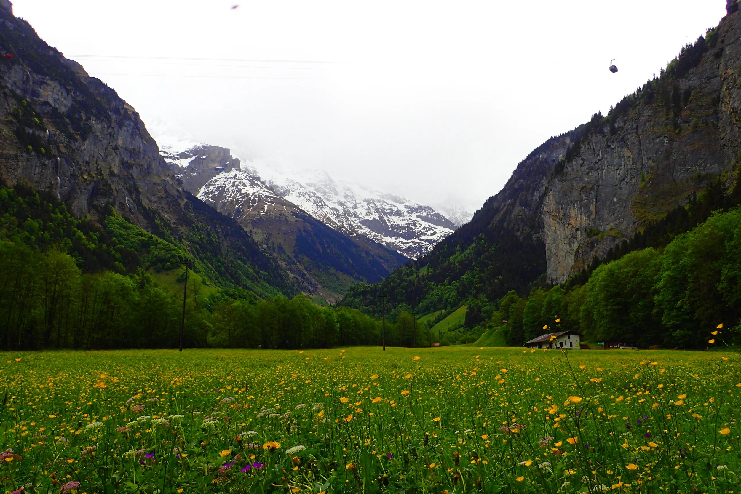
Okay, I was ready to ride up to Mürren.
Another day, another gondola ride! This wasn’t just any gondola ride, though—it is the world’s steepest! At about $16.50 one way, it has a gradient of 159.4%. My brain still can’t process how cable cars work. How do they clear the cliff edge so seamlessly??
The photos below give a sense of just how steep was!
I walked through the main path in town to get to a viewpoint. On the way, I found myself stopping over and over to admire the adorable decor around people’s homes and businesses. Little wooden carved owls, manicured gardens, and other charming ornaments grabbed my attention along the way.
At the lookout point, I sat down on a rock wall and ate some snacks I brought along. From this vantage point. I could watch paragliders taking off from the hill near the cable car and drifting across the misty expanse, down into the valley.
At one point, a friendly, domestic cat in a bowtie joined me for lunch and to take in the views. I couldn’t help but think what a lucky cat he was! He gets to greet tourists and boast about the beautiful mountain views he gets to witness every day!
I decided to hike part of the way back down instead of taking the cable car back. Different villages in the area are connected by cable cars. I was able to walk beautifully maintained winding paths down to the next village over of Grimmelwald (not to be confused with yesterday’s Gindelwald!).
The way there included beautiful gardens in front of people’s homes, lots of cows, and mountain views to die for.
In Grimmelwald, I waited for the next cable car by exploring the town a bit. It was just as charming as Mürren. My favorite part was a self-service souvenir store called The Honesty Shop. The door was open and there were no staff or cashiers inside. Every item is labeled with the price. You pick what you want and simply leave money for it in the box. What a beautiful concept!
I rode my final cable car in Switzerland back down to the bus stop and headed home.
That evening, I treated myself to the best chocolate fudge gelato I’ve ever had from Cocox (a Swiss Chocolate shop) and called it a night!
In Conclusion
Every day, I accessed a new part of the Interlaken region with a mixture of public transportation, hiking, and gondola rides. Even though it was May, when many higher altitude hikes were inaccessible, there was still so much to do and some great benefits to being there during shoulder season.
I was thrilled with all of the access I had to stunning viewpoints from pretty much any vantage point. But this isn’t all I did in Interlaken. I also went there for one very specific experience. Learn more about what I did my first day, which almost made seeking views obsolete for the rest of my stay!

Taking a little break from Costa Rica this week to bring you some extra content from my trip to Santorini!
On our last day in Greece, on the island of Santorini, Carolina and I decided to explore one last area. The Akrotiri peninsula includes a few nice highlights that are worth the bus ride down for part of the day.
We went to the red beach and to the Venetian Castle of Akrotiri. Both of these were free to visit. We had the option to also visit the Akrotiri Museum but we opted not to. Sometimes there are certain highlights that I choose to pass up on trips especially when they cost money. The fee and not feeling enthusiastic enough about the museum turned us away.
Otherwise we had a nice visit to Akrotiri before we departed for our next adventure in Sweden and Norway!