Planning ahead has worked very little on my trip. Going with the flow, allowing each moment to take me in new directions has always proved to lead to the best experiences.
So when Carolina told me she was going to have to fly into Christchurch instead of Queenstown, I simply shrugged my shoulders and said, “See you there!”
This change in plans took me and Birgit on another route deviation. We were at the perfect junction to turn inland from the West Coast and cross the center of the South Island back over to Christchurch.
We ended up traveling along New Zealand’s Great Alpine Highway. This area of the Canterbury region was so spectacular and filled with adventures, it was worth retracing the route with Carolina a week later. From pie-eating and caving to camping and hiking, these are the highlights from my Great Alpine Highway drive.
1. Sheffield Pies
Carolina, a Swedish woman I met and road tripped with in Iceland, was now sitting passenger for a road trip in Frogger around New Zealand's South Island. Birgit had stayed behind with some friends in Christchurch. We had all hung out the night before and said our goodbyes.
Now we were on Route 73 with plans to stop at Sheffield Pie Shop for a bite to eat.
I was told Sheffield Pies have some of the best pies in the area and possibly the whole country! Meat pies are like a national dish in New Zealand. Carolina hadn’t tried any yet since she had only arrived a few days prior and I had driven right by the place the two times I had already been out this way.
Walking in, there was a huge display case filled with all sorts of pies—both savory and sweet.
I tried a chicken, potato, and mushroom pie. It was definitely worth the stop.
2. Cave Stream
The ride from the pie shop to our first destination wove up a mountain side overlooking a valley next to Korowai-Torlesse Tussocklands Park. The view was our first taste of the dramatic Southern Alps we were going to witness over the next two days.
We passed by Castle Hill—we’d head there later—and went straight to the Cave Stream Scenic Reserve. A small car park in the middle of an open field looked like nothing much. But a short walk down the hill took us to the mouth of an enormous limestone cave.
When I think of a cave this is what I have always pictured!
The water at the entrance was waist-deep and cool—refreshing after the walk down in the blistering summer sun.
With our headlamps on, we made our way into the pitch darkness pushing against the current of the stream water.
The limestone in the cave was sculpted into unbelievable arches and sweeping corners. Where strong currents had once beat against the rocks repeatedly, the limestone was etched with ripples like wood chipped carvings.
We could explore off-shoots from the main tunnel. At one point, we heard people coming up behind us in the cave. Carolina and I huddled inside one of the holes in the wall until they came by and—“RAAAHHHH!!!” We jumped out and scared their headlamps out. Well, no, their headlamps didn’t go out, but that’s what would have happened if this was a cartoon. The couple we had scared had a good laugh with us over it and then continued on ahead.
The stream was strong in several parts of the cave. We seemed to be heading up hill slightly which meant there were waterfalls to climb in various spots. The water was so strong it actually untied our shoe laces several times over!
After about 45 minutes, we could see light at the end of the tunnel. A driftwood sculpture was propped up against a wall on the way out to a large pool of water near the entrance. We had to climb out up metal rungs haphazardly nailed into the rocks and then crawl out on hands and knees.
Such an adventure! Our clothes were heavy with water and our skin was clammy and cold. I welcomed the heat from the sun on my wet hair and clothes on the walk back to the car park.
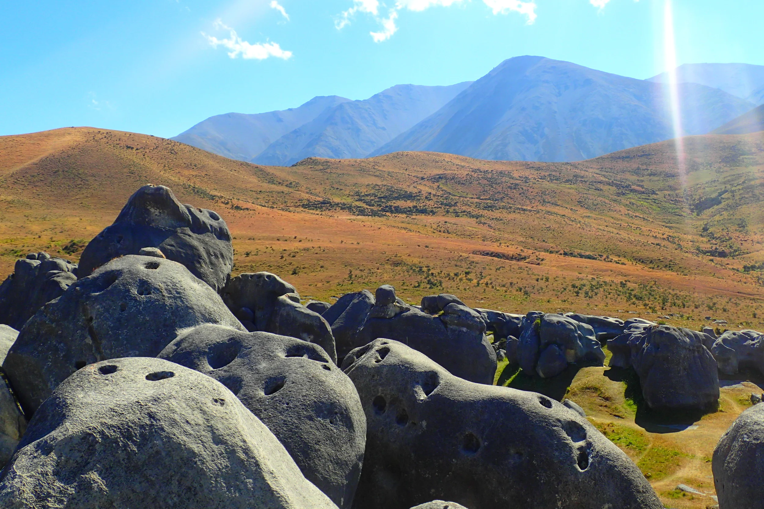
3. Castle Hill
We backtracked down Rte 73 about 1 km to continuing drying off at one of my favorite locations in the South Island—Castle Hill. Castle Hill is just a short walk up from the road. The area is covered with hundreds of enormous limestone boulders dispersed all over the place. It happens to be one of the film locations for Narnia: The Lion, the Witch, and the Wardrobe.
You can spend hours here exploring between the boulders, climbing on top of them, and just taking in the 360-degree views.
I’ll let the photos speak for themselves…
This was my third visit to Castle Hill. I had been there previously with Michaela, my couchsurf host in Christchurch, and with Birgit just a week before.
But it was worth it returning for a third time especially because we found out there was a forest fire nearby. This made for a dramatic scene for my lens—especially with this epic filter turned on:
4. Lake Pearson Camp
Originally, we were going to keep driving all the way to the West Coast, but the forest fire was in full swing when we finished up at Castle Hill.
The road was closed and a line of cars was developing. There was a 2 hour wait in which we got to stand outside the car and watch all the action taking place.
Helicopters were taking water from the lakes to put out the fires. It was exciting getting to see them up so close.
Eventually we made it to a campsite at Lake Pearson. This location was really lovely at the foot of Purple Hill. There was great cover under trees and plenty of room for other campers to spread out nearby.
Ducks greeted us both when we arrived and for breakfast the next morning!
5. Bealey Spur track
The next morning, Carolina and I were on the lookout for a good trail to hike. Any hikes that go up were bound to have amazing views.
Eventually we spotted signs for the Bealey Spur track. I knew nothing about this track, but the area was beautiful and the direction of the track went up and up.
First, the trail went through mountain beech forest and then it opened along a ridgeline looking down on Bruce stream.
Carolina is a bit of a daredevil when it comes to ledges of cliffs. You can get a good idea of our altitude and the steep drop from this shot.
The trail continued through grasslands and passed mountain tarns (or lakes). At this point, the views of the Southern Alps came into sight. We could see the entire glacier-carved valley below.
Other hikers passing by asked if we were going to stay at the hut at the top. “No, but how is it?” Apparently they had slept over there the night before and said it was filled with rodent droppings! We had a laugh and then continued the last half hour up.
After a total of 2.5 hours of hiking we made it to the hut. The amenities were pretty rugged, but I could see it being a saving grace to some hunters caught in a storm in the winter.
We signed the book inside, ate a snack on some logs out front, and then made our way back down to the car park.
This hike was completely worth the climb for these views overlooking the Waimakariri River valley.
Why driving was the best method
While we chose to drive across the South Island, one does have the option to take the Tranzalpine Kiwirail to make the trip from East to West. Tickets start around $130 to do it.
But driving it in Frogger, our rental car, allowed us to dwell as long as we wanted, where we wanted, and at our own pace. We never would have had the chance to see all of the above and more if we were confined to a train car.
The rest of the drive on the Great Alpine Highway included many beautiful sights just from the road side. We could get out and take photos freely at any point.
We were able to stop at a lookout along Arthur’s Pass to get a glimpse of the amazing, earthquake resisting Otira Viaduct…
And we could stop for a swim in the cool, ice-cold water of Deception River…
After so much to see and do along this 231km stretch of road, this was the most effective mode of transportation in which to experience it!